Visualizing Student Journals

As students are journaling more and more during the COVID-19 school closures, their words offer valuable insights into their daily lives and the social-emotional challenges they face.  One way teachers can get a quick visual handle on how students are feeling is to upload typed journal entries into platforms that create word clouds and other text mining functions.  Voyant-Tools, a free platform, offers far more capability than just creating a word cloud (cirrus), but for student use, it can be used in a rather simple form. This guide explains how to get started. Or, watch the video demonstration.  After students create their cirrus or word cloud, they can send an embedable link to the teacher or take a screen shot.  Teachers could also collect student responses using Padlet or similar services.


Uncovering Viking History

Uncover Viking History

Maker Thinking Using the Vale of York Hoard

My students are loving this unit I developed for my class Digital Humanities in Education.  Students act as museum interns to help solve a “history mystery” when two metal dectorists discover a large bucket of coins and other materials in a field in England.  Borrowed from the true story of the discovery of the Vale of York Hoard and using images licensed for use by the British Museum, students walk through the process of historical thinking skills as they learn about the fascinating history of the Vikings.

AAA Travel Roman Style

One of the great practical resources I’ve come across while studying Digital Public Humanities is ORBIS:  The Stanford Geospatial Network Map of the Roman World.  It is a great tool for visualizing trade and travel in the Roman world, but it is an especially rich tool for young people in understanding the differences in cost and time in traveling over land or by water.  It also served as the opportunity to get to know some of the great Roman ruins/functioning architecture still in existence today.

Each student was assigned one of the UNESCO World Heritage sites highlighting Roman ruins.  Each student did a bit of research on the site’s significance and then mapped its distance from Rome in ORBIS.  Students shared their information with each other digitally and in a class discussion.  Using their collective resources, students created ThingLink maps illustrating travel times between places of cultural, historical or military importance in the Roman world that we can still visit today.  Viva, digital history! Here is an example of one student’s work.

The Liberties and Limits of Digital History

I am so grateful for being a teacher in the digital age when resources abound for teachers to incorporate into the classroom in able to make “hands-on” history classes.  I am particularly enamored with the resources at the Getty Museum, the British Museum and Google Arts and Culture.  Using these resources, I’ve been able to craft some “pre-DBQ” questions for my middle school students to help them to think critically about the messages that historical artifacts, such as coins, might convey and how we can learn to “read” history visually.  I especially like the toolkit of Artful Thinking activities provided by Harvard’s Project Zero.

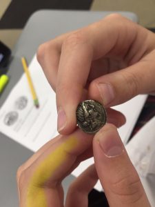
While I was travelling last summer, I picked up some reproduction Roman coins to make the history more real for my students.  And so, in my classes last week, students passed around these replicas of coins that correlated to the digital versions accessed through the above mentioned sites.  The exercise was all the more real for them because they could explore the coin with all their senses in a way that the digital reproduction could not.  However, the digital copies emanating from their iPads allowed them to explore the same “virtual coin” at the same time and to zoom in on details that would have been difficult to see otherwise.

But, one lucky student happened to be holding a real Roman coin, on classroom loan from the family of a former student whose grandfather was an amateur coin collector.  I am grateful for their willingness to share this “hands on” opportunity with our school community.

Denarius of Julius Caesar with Venus on obverse, probably minted in Gaul or North Africa, circa 50 BCE.

I believe in the power of digital history to bring the world into modern classrooms.  But, nothing will ever substitute for the ability observe the real thing, and in the case of my students, to actually hold the “real deal” in your hand.  Touching and, yes, even smelling it, students stare in wonder as they consider all the pockets and places the coin has traveled in its two millennia of existence.  I am a lucky teacher to have access to both the analog and the digital versions of this ancient artifact.  While the digital will never replace the real thing, it can enhance access to a broader group of people and enhance the ability to look carefully into the past.

Learning World War II by Understanding Sacrifice

Delivering the eulogy for Lt. John Anthony Boronko, Florence American Cemetery, Italy

So, I realize that it’s been a while since I last posted what’s been going on in my teaching life.  Quite a lot actually!

In 2015-16 I was fortunate to join seventeen other teachers from across the United States to participate in a program meant to reinvigorate teaching about World War II in classrooms across the world.  Understanding Sacrifice is a joint project between the American Battle Monuments Commission, National History Day and the Roy Rosenzweig Center for History and New Media (RRCHNM) at George Mason University. I researched the life of Lt. John Anthony Boronko who served in the Mediterranean Theater as a C-47 pilot and developed a lesson plan showing how pilots’ souvenirs called short snorters help to document the experience of some of those who fought in World War II.  You can read more about that journey here.

I’m excited to use what I’ve learned and the learning of the three Understanding Sacrifice cohorts to teach an elective class next fall about World War II through the perspective of its Silent Heroes.  One of the things that I took away from my time in Europe during the summer of 2016 was how local communities in Europe have banded together to adopt the graves of soldiers buried in the ABMC cemeteries.  I am hoping that we will be able to take a field trip to the RAF cemetery at  in Terrell, Texas, in order to pass along some of the same level of remembrance here in North Texas.

The Arctic World’s the Stage …

In my last post, I referenced Shakespeare’s idea that “all the world’s a stage” and that humans are merely actors on a stage that doesn’t shift (much) geographically. That is, unless, technology is involved. The Douglas C-47 Skytrain definitely changed the geography of World War II – more “easily” flying the Hump to resupply China than navigating the Burmese Road, a mess of ruts through the Pat Kai range at the eastern edge of the Himalayas.

This week, my students have been assessing 45 locations in the world in terms of their ability to isolate, integrate or create choke points for humankind over the last 2,000 years. One of those locations is the Arctic Ocean. Generally speaking, it’s been lurking up at the top of the world with the label of ISOLATION, an easy moniker for such a frozen place.

But, this week, my students get to see how this theme of movement is played out in their own history – in the world of energy hungry, Gortex and Hy-Vent wearing, nuclear fueled navies competing for territories and resources at the top of the world. Our northernmost border, often overshadowed by the difficulties at the southern border of the United States, is in the spotlight as our president is going FAR north to stake a claim on an area that technology has opened.

Teaching mental mapping is critical to equip students to navigate their own futures and the future of their world.

Mentally Mapping the World

One of the National Geography Standards is a concept called mental mapping – the idea that as citizens of the world, we should be able to “mentally organize spatial in­formation about people, places, and environments and must be able to call upon and use this information in appropriate contexts.”  It’s an important skill whether you are evaluating a situation around the corner or across the globe.

This week we’ve been working through 45 locations in Europe, Africa and Asia that will be important as we explore the ebb and flow of history across the last two thousand years in that part of the world. I want students to understand, in the words of Shakespeare, that despite the fact that “all the world’s a stage,”  the geography doesn’t change (much).  The women and men who have been fleeing from Turkey and Syria across the Mediterranean to EU nations in 2015 are reversing the same paths their predecessors traveled as they fled from the ashes of Rome across Mare Nostrum  to Constantinople in the 5th century.  Yes, the individuals and technology of travel have changed, but the geography remains much the same.

So, armed with an iPad for apps like Google Sheets, Keynote and ImageQuest, as well as an old-fashioned spiral of lecture notes about the geographic themes of location, place and movement, my students are creating Thinglink maps.  They are identifying the various locations by creating a pop-up slide for each one.  They must describe the physical characteristics of the place in terms of how it might influence the choices the people living there might make about daily life today or in the past and include a photo that is representative of their text.  They are also aware of how relative location might influence the movement of people, places or ideas.

It takes some time, but we will be able to refer back to the maps throughout the year to trace the influence of geography as we march through 2,000 years of history in 36 weeks. And, hopefully, we can make some connections along the way to the world they are living in today.


Getting a handle on “thehistoryhead”

arthead

The ArtHead

My friend and colleague, Denise M.A. Brown, is a wonder to behold in and out of the classroom.  She is a dollar store diva and re-purposes cast off wood into the most beautiful and thoughtful art.  She also teaches elementary art just down the hall, and as students move through her classes from year to year, she tells an increasingly elaborate tale about a small plastic trinket she received as a child from an old-fashioned coin operated prize machine. While she had saved up her shiny coins to obtain the coveted red plastic horse, she was beyond disappointed when a ring came spilling out of the metallic mouth of the machine.  Just as she was about to throw it in the gutter, she saw a glint of color – a picture of a small dog embossed on the ring.  She began to look more carefully and realized that someone had made that ring with – PURPOSE.  What she had originally seen as trash now became a treasure because she had the eyes to carefully look carefully at what she was holding.  When one of her students does well in class, Denise allows him to pick a plastic trinket out of the ART HEAD, a recycled Operation™game component.  He’s not allowed to trade it out for something else because he needs to recognize the PURPOSE with which it was made.  Denise is a gifted story teller, and she uses the tale and the tokens to illustrate to her students the importance of their own purposeful choices when creating art in her classroom.  So, what does an art class have to do with history? (Quite a lot, actually, but that’s another post!)

cropped-history-head-1oy1pwc.jpg

The HistoryHead

In reading John Fea’s Why Study History?, I began to think about how to teach my students how to “become historians” rather than merely to be students in a history class.  Hearing Denise’s lesson-in-a-tale inspired me.  The kids already knew the story by heart so why not add on a chapter about looking with PURPOSE historically?  So, I got a Styrofoam head, a wig, a fake mustache and some googly glasses to create the HISTORY HEAD. The students and I discuss how important it is to look carefully, as if our eyes were popping out of our heads, at primary source materials to discover their purposes.   It’s a goofy lesson, but my students practice from the beginning that true learning about history demands careful observation.  Primary source objects and documents have the power to show us the varying purposes at work in history, if only we have the eyes and minds to see.